STORY YOUMISSED


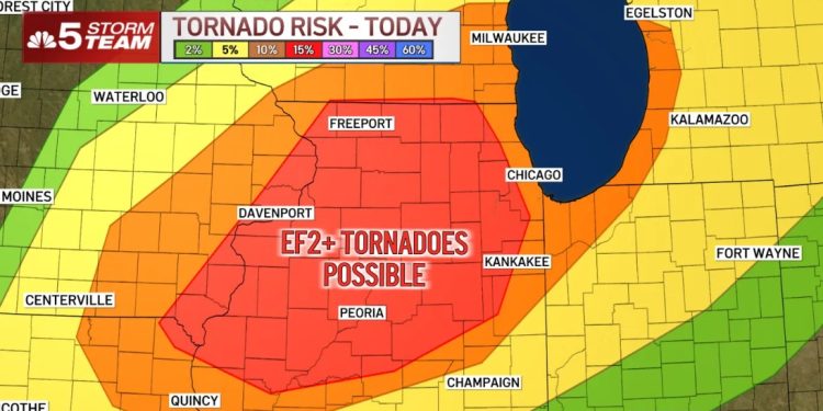
The National Weather Service has upgraded the entire Chicago metropolitan area to a Level 4 out of 5 risk for severe storms as atmospheric conditions align for a potentially dangerous tornado outbreak Thursday afternoon and evening.
A comprehensive Tornado Watch remains in effect until 9 p.m. for Illinois residents across Boone, Cook, DuPage, Grundy, Kane, McHenry, De Kalb, Kankakee, Lake, La Salle, Kendall, Livingston, Lee, Ogle, Will, and Winnebago counties.
Neighboring Indiana communities face the same imminent threat, with Benton, Jasper, Newton, Lake, and Porter counties included under the watch perimeter.
Immediate severe weather impacts hit Northwest Indiana early in the afternoon, prompting Severe Thunderstorm Warnings for Lake and Newton counties until 3:15 p.m., and Jasper and Porter counties until 3:45 p.m.
Atmospheric parameters show the first of two strong thunderstorm lines advancing through the region after midday, dropping the heaviest rainfall and highest wind speeds across the south and southwest suburbs before pushing directly into Northwest Indiana.
Meteorologists tracking the system noted a troubling development at approximately 2:15 p.m. as radar data showed signs of tightening rotation, signaling that local atmospheric conditions are highly favorable for rapid tornado formation.
Weather authorities explicitly warned local residents that the regional threat for tornadoes is notably higher Thursday than during typical severe weather events.
The National Weather Service emphasized that the enhanced environment supports the development of more dangerous and violent tornadoes, which carry the potential for catastrophic EF-4 and EF-5 intensity ratings.
This declaration marks the first time the Chicago region has been placed under a Level 4 risk since July 15, 2024, when a historic derecho and severe weather sequence triggered a record-breaking 32 confirmed tornado touchdowns across the area.
WATCH VIDEO BELOW.
Forecasters note that a Level 4 weather risk is an uncommon occurrence for northeastern Illinois, typically materializing only once every two years.
In addition to the tornadic threat, torrential downpours have prompted a region-wide Flood Watch for all Chicago-area counties, alongside Lake and Porter counties in Indiana, remaining active until 11 p.m.
Senior meteorologists report that the window of maximum danger will open between 4 p.m. and 8 p.m. as intense summer heat, surging humidity, and high-velocity atmospheric winds combine to supercharge the storm system.
While the weather service expects a widespread outbreak across the entire viewing area, advanced modeling places the highest statistical risk for significant tornado touchdowns in the densely populated western suburbs.
Local municipalities are urging residents to review their emergency safety protocols immediately before the primary line of cells impacts local neighborhoods.
The federal weather agency distinguishes a tornado watch as an indication that conditions are ripe for a tornado to form, whereas a tornado warning means a touchdown has either been detected by radar or confirmed visually on the ground.
Emergency officials state that if a tornado warning is issued for a specific community, residents must take instantaneous action to protect themselves, their families, and their household pets.
Property owners should immediately seek shelter in a basement or move to the absolute lowest floor of the structure, positioning themselves inside an interior room completely isolated from windows.
Safety guidelines emphasize putting as many structural walls as possible between individuals and the outside elements to mitigate the extreme danger of flying debris.
Residents living in multi-story public buildings or single-family homes without basement access should migrate to small, central spaces such as bathrooms, closets, or first-floor interior hallways.
Unsafe exterior doors leading into hallways should be pulled shut tightly, and individuals should attempt to shield themselves beneath heavy, sturdy furniture.
Meteorologists advise using everyday household items like pillows, thick blankets, and heavy quilts to create a protective barrier against shattering glass and moving debris.
Local emergency managers recommend that residents who own bicycle or motorcycle helmets should wear them during a active warning to prevent severe head trauma.
Individuals residing in mobile homes should actively vacate their properties well in advance of the storm line to secure reliable shelter inside a permanent, structurally sound building.
Drivers caught outside or inside a vehicle during a touchdown must seek out the nearest low-lying ditch or underground culvert, lie completely flat on their stomach, and cover their head with their hands.
State transportation officials strictly warn motorists never to take shelter underneath highway overpasses, as the narrow structural openings create a dangerous tunneling effect that accelerates wind speeds.
Residents across the region should keep cellular devices plugged into chargers throughout the evening and assemble a mobile emergency kit containing bottled water, flashlights, a battery-powered radio, and essential prescription medications.
This dangerous weather setup arrives while local infrastructure is still recovering from a series of violent Wednesday storms that tore through Chicagoland neighborhoods, snapping mature trees and shattering utility poles.
ComEd field crews reported more than 5,600 active electricity outages early Thursday morning, with the initial wave of severe weather impacting nearly 200,000 commercial and residential customers.
Utility executives stated they expect to have 80 percent of the remaining storm-related electricity outages successfully restored by 11 p.m. this coming Saturday.
Homeowners can monitor localized repair timelines and register for active grid alerts by visiting the official ComEd outage map online.
Wednesday’s initial storm damage manifested visibly across the suburbs, with lightning strikes igniting a residential house fire in Orland Park and high-velocity straight-line winds ripping a roof section off a commercial building in Stickney.
Regional weather conditions will improve significantly on Friday as high pressure brings a return of sunshine and a welcome drop in humidity levels.
The calm weather pattern will persist through the first half of the weekend before an additional line of thunderstorms moves into the area late Saturday night.
Forecasters warn that the secondary Saturday night system could also turn severe, with large hail and damaging straight-line winds tracking as the primary convective threats.


